

Wave height calculation
 01-26-2021, 10:19 PM
#21
Gold Member
[QUOTE=thisistank;4775062]
I don't think that's accurate. Swell height from every scientific chart I've ever seen measures from the bottom of the trough through the point of sea level (like you're stating approximately mid section) to the crest.
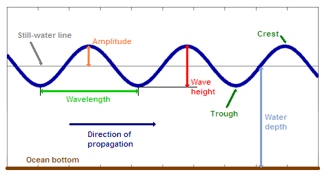
I agree with you 99%, that is the preferred way to measure wave height. It’s accurate and simple.
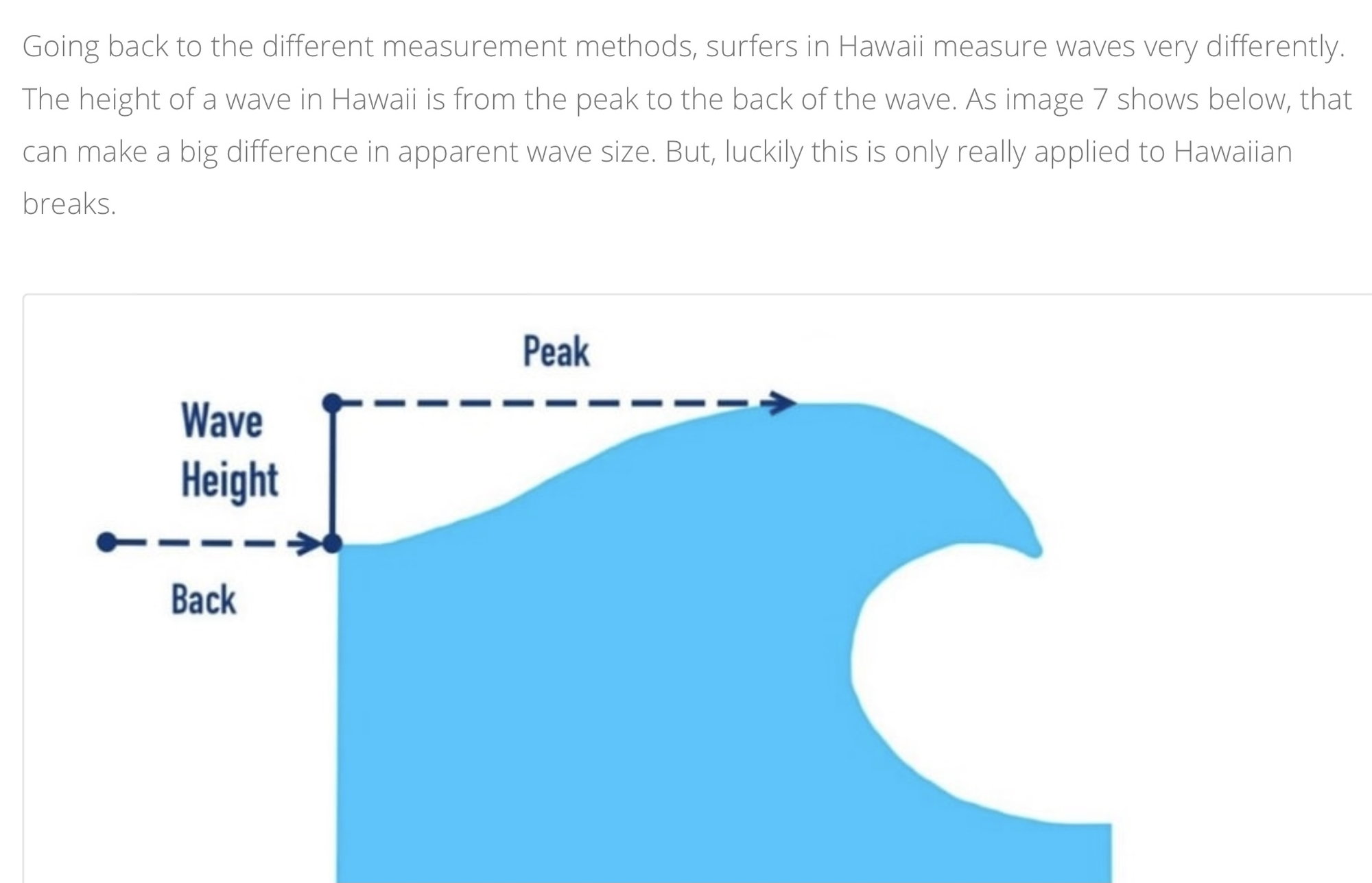
Many moons ago, I was taught the “Hawaiian Method”. It was commonly used in Australia, probably because Aussie surfers idolized Hawaii! I guess from the replies here, my method is outdated, which means I can now double the size of the waves I’ve seen when telling stories from my past......😆
Here’s the Hawaiian Method, measures off the back of the wave, not quite as I described previously but not too far different either.
I don't think that's accurate. Swell height from every scientific chart I've ever seen measures from the bottom of the trough through the point of sea level (like you're stating approximately mid section) to the crest.
I agree with you 99%, that is the preferred way to measure wave height. It’s accurate and simple.
Many moons ago, I was taught the “Hawaiian Method”. It was commonly used in Australia, probably because Aussie surfers idolized Hawaii! I guess from the replies here, my method is outdated, which means I can now double the size of the waves I’ve seen when telling stories from my past......😆
Here’s the Hawaiian Method, measures off the back of the wave, not quite as I described previously but not too far different either.
Last edited by rak rua; 01-26-2021 at 11:26 PM. Reason: Spellnig

The following 2 users liked this post by rak rua:
hoodoo (01-27-2021), thisistank (01-27-2021)
01-26-2021, 10:51 PM
#22
I just uploaded that "Windy" app on my phone - it's awesome! Thanks for the tip guys! I've been using "Windfinder Pro", and it doesn't have near as much information as "Windy". For what it's worth, wave height in open water is definitely measured from the trough to the peak, that is the information/vertical-distance-traveled that the buoys send to the satellites to relay/record wave height. For breaking waves along shoreline (surf), I'm honestly not sure if the wave height is measured from the front or back side of the wave. All I know is that most performance boaters WAY over-estimate the size of the water they run in. If I had a dollar for every guy that says his 28' center-pod cat runs over 4 footers like nothing, I'd be rich!
The following 5 users liked this post by Skater30:
hoodoo (01-27-2021), PigNaPoke (01-27-2021), sutphen 30 (01-27-2021), thisistank (01-27-2021), Wally (01-27-2021)
01-27-2021, 05:45 AM
#23
Registered
Join Date: Feb 2012
Location: Sarasota FL. Priest River ID
Posts: 1,131
Received 1,286 Likes
on
474 Posts
[QUOTE=Skater30;4775158]For what it's worth, wave height in open water is definitely measured from the trough to the peak, that is the information/vertical-distance-traveled that the buoys send to the satellites to relay/record wave height. For breaking waves along shoreline (surf), I'm honestly not sure if the wave height is measured from the front or back side of the wave.
This is how I have always understood it, offshore waters referred to as seas and measured by the total buoy movement.
Waves occur when the swells contact the reef or sandbar.
I�d need a really good reason to go offshore when the NOAA forecast is anything over 2�.
This is how I have always understood it, offshore waters referred to as seas and measured by the total buoy movement.
Waves occur when the swells contact the reef or sandbar.
I�d need a really good reason to go offshore when the NOAA forecast is anything over 2�.
 01-27-2021, 11:49 AM
#25
Registered
We boat in Galveston bay and the Gulf most of the time. I use the Ventusky app for wind and wave height to decide our destination based on my passengers ie granddaughter's and so on. That said we went out a while back and my app said wind wave height was 1.2 footers so pretty flat. When we hit the bay they were 3 footers plus Surprise. I noticed there is a selector on the app for wind wave height and swell height and spacing. Am I to assume that wind wave height is calculated on top of the swell height. So to accurately assess conditions they need to be added together? I look at conditions like wind direction as it changes where we launch
02-01-2021, 12:04 PM
#26
CBPBA's Walmart Greeter
With a 1990 34' Scarab for 20+ years, generally, we eventually stopped paying any attention to wind/wave forecasts. But started the practice with our 18' CC and a 370 SS.
Today I add a foot or so to the forecast wave height when winds will be steady in the teens (mph), 2 feet or more if steady above 20mph. I also consider which direction they are blowing in relation to direction we'll be traveling.
Today I add a foot or so to the forecast wave height when winds will be steady in the teens (mph), 2 feet or more if steady above 20mph. I also consider which direction they are blowing in relation to direction we'll be traveling.
__________________
K2
-----------------------------------------
CHESAPEAKE BAY POWER BOAT ASSOCIATION
'http://www.cbpba.com'
"Experience is something you don't have until just after you need it."
K2
-----------------------------------------
CHESAPEAKE BAY POWER BOAT ASSOCIATION
'http://www.cbpba.com'
"Experience is something you don't have until just after you need it."


