

Wave height calculation
 01-25-2021, 01:53 PM
#1
Registered
Thread Starter
Join Date: May 2018
Posts: 21
Likes: 0
Received 0 Likes
on
0 Posts
We boat in Galveston bay and the Gulf most of the time. I use the Ventusky app for wind and wave height to decide our destination based on my passengers ie granddaughter's and so on. That said we went out a while back and my app said wind wave height was 1.2 footers so pretty flat. When we hit the bay they were 3 footers plus Surprise. I noticed there is a selector on the app for wind wave height and swell height and spacing. Am I to assume that wind wave height is calculated on top of the swell height. So to accurately assess conditions they need to be added together? I look at conditions like wind direction as it changes where we launch


Top Answer
01-26-2021, 10:47 AM
Registered
Unless you boat on LOTO or Mead there shouldn’t be a need to be concerned with wave height.
01-25-2021, 08:14 PM
#2
Gold Member
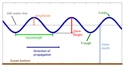
Don�t forget, most people look at a wave and say it�s 4� from the bottom of the trough to the top of the wave so it�s a 4� wave. I reckon that�s incorrect, it�s a 2� wave. The sea level is usually slightly below the middle, between the trough and the peak and a true wave height is the height above that median level. (The trough generated by wave action is not part of the wave)
Maybe your App calculates it the true way so their 2 footer might be seen by most as a 4 footer?
RR
Maybe your App calculates it the true way so their 2 footer might be seen by most as a 4 footer?
RR
The following users liked this post:
hoodoo (01-25-2021)

The following 4 users liked this post by Dave M:
01-26-2021, 10:08 AM
#4
Registered
Join Date: Aug 2001
Location: Channel Islands, So. Cal.
Posts: 13,832
Received 3,219 Likes
on
1,044 Posts
Double post
Last edited by thisistank; 01-26-2021 at 10:23 AM.
01-26-2021, 10:09 AM
#5
Registered
Join Date: Aug 2001
Location: Channel Islands, So. Cal.
Posts: 13,832
Received 3,219 Likes
on
1,044 Posts
We boat in Galveston bay and the Gulf most of the time. I use the Ventusky app for wind and wave height to decide our destination based on my passengers ie granddaughter's and so on. That said we went out a while back and my app said wind wave height was 1.2 footers so pretty flat. When we hit the bay they were 3 footers plus Surprise. I noticed there is a selector on the app for wind wave height and swell height and spacing. Am I to assume that wind wave height is calculated on top of the swell height. So to accurately assess conditions they need to be added together? I look at conditions like wind direction as it changes where we launch
Don�t forget, most people look at a wave and say it�s 4� from the bottom of the trough to the top of the wave so it�s a 4� wave. I reckon that�s incorrect, it�s a 2� wave. The sea level is usually slightly below the middle, between the trough and the peak and a true wave height is the height above that median level. (The trough generated by wave action is not part of the wave)
Maybe your App calculates it the true way so their 2 footer might be seen by most as a 4 footer?
RR
Maybe your App calculates it the true way so their 2 footer might be seen by most as a 4 footer?
RR
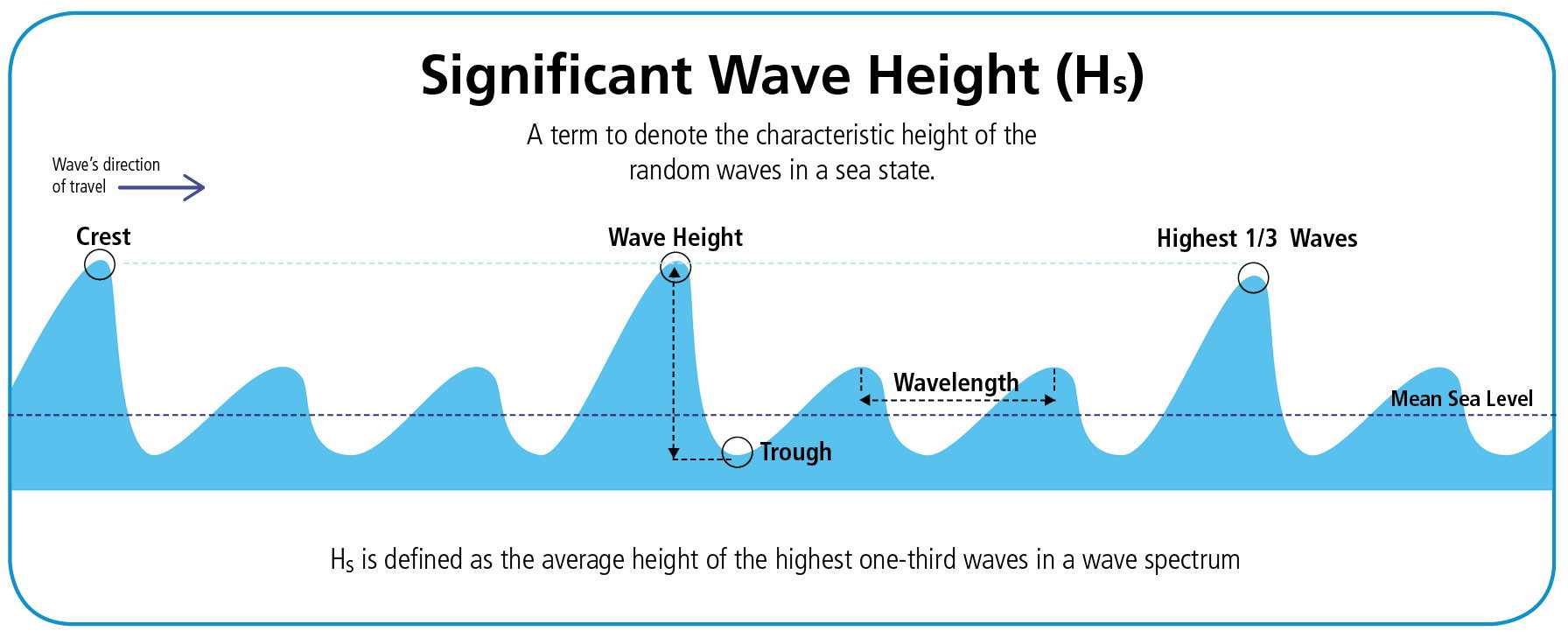
I don't think that's accurate. Swell height from every scientific chart I've ever seen measures from the bottom of the trough through the point of sea level (like you're stating approximately mid section) to the crest.
The following 2 users liked this post by thisistank:
AmiableDave (02-01-2021), thirdchildhood (01-26-2021)
01-26-2021, 10:47 AM
#6
Registered
Unless you boat on LOTO or Mead there shouldn’t be a need to be concerned with wave height.
The following 10 users liked this post by Knot 4 Me:
ALL_IN! (02-01-2021), Drock78 (01-26-2021), dykstra (02-01-2021), endeavor1 (01-26-2021), hoodoo (01-26-2021), IGetWet (01-26-2021), jbraun2828 (01-26-2021), offshorexcursion (01-26-2021), PigNaPoke (01-27-2021), thisistank (01-26-2021)
01-26-2021, 10:50 AM
#7
Registered
On Lake Michigan wave height can vary mile by mile and minute by minute . Looking at a "wave forecast" is about as accurate as the covid numbers.
The following 9 users liked this post by ICDEDPPL:
Gimme Fuel (01-27-2021), HabanaJoe (01-26-2021), IGetWet (01-26-2021), offshorexcursion (01-26-2021), phughes69 (02-02-2021), rak rua (01-26-2021), Revd Up (02-01-2021), Shotgunn (02-04-2021), Wally (01-26-2021)
01-26-2021, 11:40 AM
#8
Registered
01-26-2021, 01:21 PM
#9
Registered
i use https://www.ndbc.noaa.gov/ you can zoom in and click on the actual buoy in your area and see what the wave height and time between waves is at hourly intervals.
The following users liked this post:
AmiableDave (02-01-2021)
01-26-2021, 01:26 PM
#10
Registered
i use https://www.ndbc.noaa.gov/ you can zoom in and click on the actual buoy in your area and see what the wave height and time between waves is at hourly intervals.

